 2 hours ago
1
2 hours ago
1

9 minutes ago
Mark Poynting and Esme StallardBBC News Climate & Science

 Getty Images
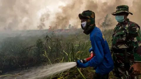
Indonesia was hit by extreme fires during the 2015-16 El Niño
A developing natural weather pattern called El Niño could begin within weeks, according to UN scientists, bringing more extreme weather to many parts of the world.
Some forecasts suggest this El Niño could end up as one of the strongest on record, which is likely to boost temperatures on a planet already made much hotter by climate change.
What happens during an El Niño and why could this one be strong?
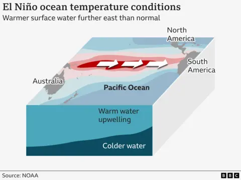
Whether we get an El Niño depends on what is happening in the Pacific Ocean and the atmosphere above it.
An El Niño develops when winds that typically blow east-to-west weaken or reverse. This allows warmer water to spread across the central and eastern tropical Pacific.
Over the past few months, scientists have observed rising sea surface temperatures in these regions. They have also noticed a drop in atmospheric pressure over the central Pacific compared with the western Pacific.
Both are classic signs that El Niño could be on its way.
The UN's World Meteorological Organization (WMO) has said it is 80% certain that El Niño will begin between June and August. Once it begins, El Niño usually lasts about a year.
Some scientists have warned that this El Niño could be especially strong, partly because the water beneath the surface of the Pacific is unusually warm at the moment - 6C above average in places.
Deep-sea heat is often followed by warmer waters at the surface. When these warm by more than 0.5C from the baseline over an extended period, conditions for El Niño are present.
Warming above 2C indicates a "very strong" or so-called "super" El Niño. These events have only happened a few times since 1950.
Some forecasts suggest the forthcoming El Niño could equal past peaks - or even surpass them - although this is still uncertain.
The El Niño phenomenon was first observed by Peruvian fishermen in the 1600s, who nicknamed it El Niño de Navidad - Christ Child in Spanish.
How could a strong El Niño affect the weather?
A strong El Niño event would "exacerbate drought and heavy rainfall and increase the risk of heatwaves both on land and in the ocean", said WMO secretary general Celeste Saulo.
During El Niño, the ocean will transfer heat to the air, making it warmer.
Coupled with higher global temperatures from human-caused climate change, this could make 2027 the hottest year on record for the planet.
The exact impact on the weather depends on where you are and what time of year it is.
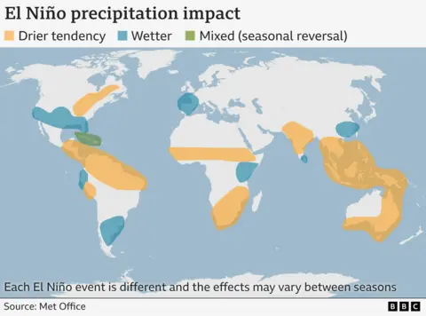
No two El Niños are the same, but a strong event typically fuels hot, dry weather in parts of South America, South East Asia and Australia, raising the chances of droughts and wildfires.
It can also weaken the Indian monsoon. In the southern US, heavier rainfall can increase the risks of flooding.
El Niño tends to bring more tropical storms in the eastern and central Pacific, but fewer in the tropical Atlantic, including the south-east US.
The way UK weather is affected is complicated, and can vary. But El Niño may increase the chance of a mild start and cold end to UK winter, according to the Met Office.
What impact could El Niño have on people?
The UN's secretary general, António Guterres, has warned the world to prepare. "El Niño conditions will pour fuel on the fire of a warming world. Impacts will hit even harder, travel even farther, and cross borders with devastating speed," he said.
Droughts in parts of South America and South East Asia could hit crops at a time when the effective closure of the Strait of Hormuz is already disrupting the distribution of fertiliser. This could mean smaller harvests, reduced food supply and higher prices.
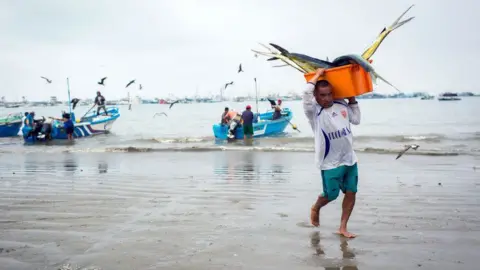
For fishing communities in South America, there is the risk of smaller catches. During El Niño, less cold, nutrient rich water comes to the surface, reducing food availability for marine species such as anchovies.
Some scientists are drawing comparisons with the 2015-16 El Niño, one of the strongest ever recorded.
At that time there were water shortages in the Caribbean, a record-breaking storm season in the central Pacific, and drought in the Horn of Africa.
The combination of storm events and widespread drought led to food shortages across the world. Millions of people in Sudan and Haiti were reported as acutely food insecure, according to the UN's Food and Agricultural Organization.
 Getty Images
Fishing stocks can be affected by the effects of El Niño
Is climate change affecting El Niño?
El Niño events since 1950 have been stronger than those between 1850 and 1950, according to the UN's climate scientists, the IPCC.
But it said that tree rings and other historical evidence show there have been variations in their frequency and strength since the 1400s.
The IPCC said there is no clear evidence that climate change has affected El Niño events.
Some climate models suggest that El Niño episodes could become more frequent and more intense as a result of global warming - although this is a complex and uncertain area of science with no clear consensus.
But the impacts of El Niño will occur on top of those from long-term climate change - which could fuel increasingly severe weather extremes.

El Niño has a sister weather pattern called La Niña.
During these events, the temperature of the surface of the sea in the central-eastern Pacific is cooler - the opposite of what is seen during El Niño.
Atmospheric pressure is also higher than usual in the central Pacific, and lower than usual in the west.
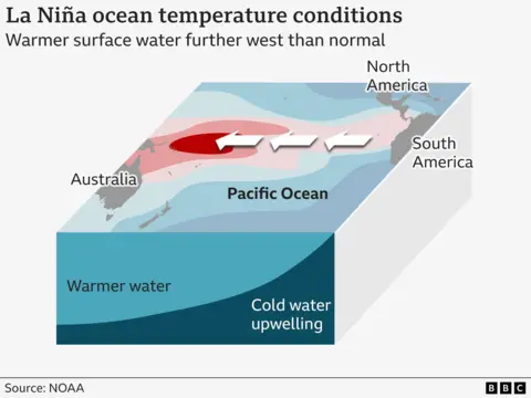
La Niña typically brings wetter conditions to parts of Australia, Indonesia and equatorial South America, and drier conditions to the southern US.
El Niño and La Niña often alternate, but sometimes we can have two of the same event back to back. On average, they occur every two to seven years.


 English (US) ·